
The World’s Largest Peatland Complexes
An introduction to the top 3 – the peatlands of the West Siberian Lowland, the Hudson Bay Lowland, and the Congo Basin

My recent internet search for the ‘world’s largest peatland’ produced the Congo Basin peatlands as the main result, in both the AI overview and in the links further below. The AI overview also included Canadian peatlands (overall) as a result. This is all very wrong! The only correct result was the Great Vasyugan Mire as the largest single continuous peatland in the world.
Based on this internet search, I can understand why I am often asked if the Hudson Bay Lowland (HBL) is really the second largest peatland complex in the world! I can confirm that it is. I completed an in-depth review of all the literature for the HBL for my PhD research some years ago now, and have double checked the status more recently as part of my ongoing research in the region. While recent mapping efforts in the Congo and Amazon Basins have produced larger area estimates for tropical peatlands, the HBL remains the second-largest peatland complex in the world.
To help clarify the ranking of the world’s largest peatland complexes, and to provide a quick reference for anyone wanting to avoid the error-ridden AI search tools, I have manually searched (ignoring any AI trying to help me, its frustratingly persistent!) and read through the available literature, old and new (including actual hard copies of books), and tried to pull out all of the key numbers for the world’s largest peatland complexes.
As expected, this was not an easy task. I found multiple credible sources reporting very different numbers for peatland area, depths, ages, and carbon stocks. Part of the problem is that peatland mapping can be limited for some regions, and some results are based on remote sensing and modelling with limited field data for validation. So, I’ve included the range of estimates where necessary.
And the correct results? Any list of the world’s largest peatlands, or peatland complexes*, should have the West Siberian Lowland (Russia) at the top, followed by the Hudson Bay Lowland (Canada), and then the Congo Basin.
*A peatland complex is an area or region of near-continuous peatland cover, where separate peat landforms (e.g., bogs, fens, swamps, permafrost peatlands) are immediately adjacent to each other and separated in places mainly by streams and rivers.
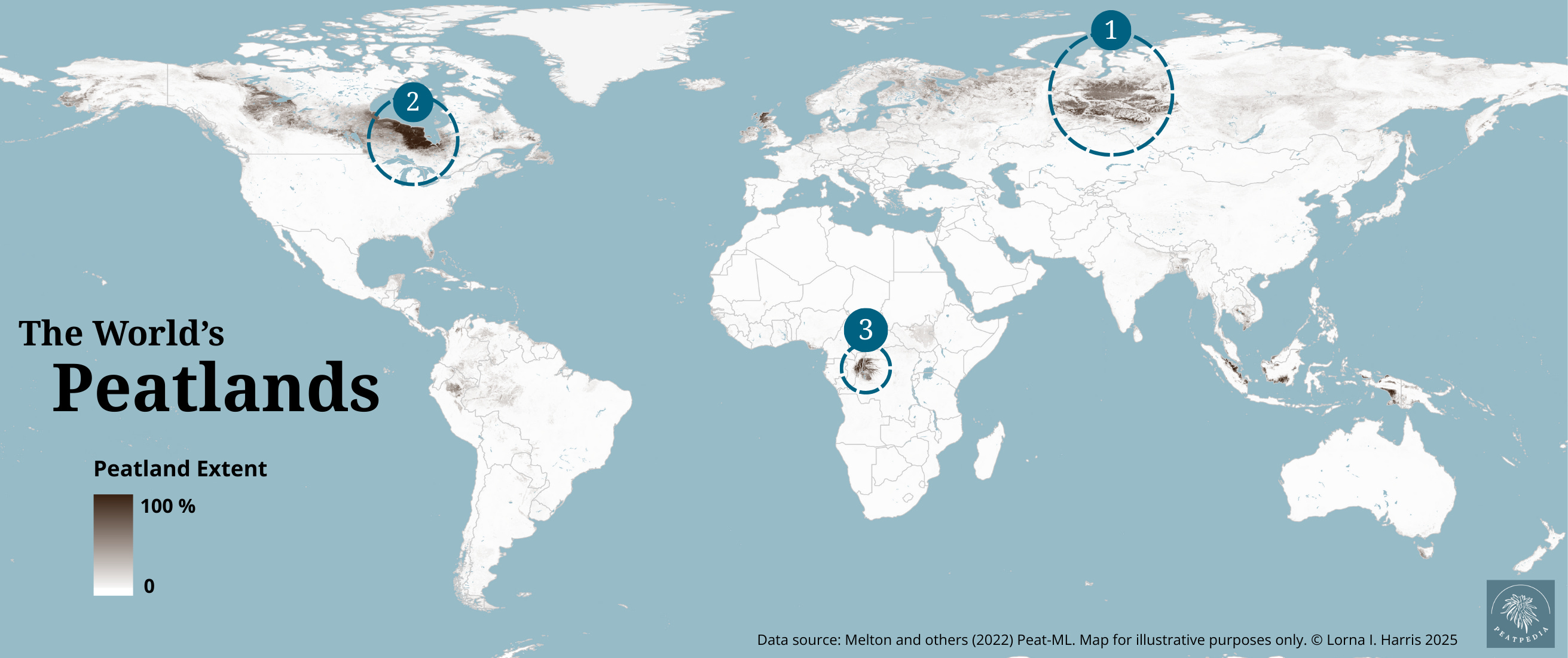
1. West Siberian Lowland
Peatland area: ~592,440 km2 to ~900,000 km2
Peat carbon stock: ~53 to ~70 Gt C
Average peat depth: 2.56 m
Deepest peat: ~7 m
Oldest basal date (when peatlands started to develop): ~10,000 yrs BP
Main peatland types: bogs, fens, permafrost peatland plateaus and palsa
The West Siberian Lowland (WSL) in Russia is the world’s largest wetland and the world’s largest peatland complex. The WSL covers a staggering ~2,745,000 km2, with up to ~900,000 km2 of peatlands. The Vasyugan bog (or Great Vasyugan Mire) is located within the WSL and is the largest single peat landform in the world, covering ~55,000 km2. The Vasyugan bog is a continous peatland that has formed from lots of smaller peatlands that have merged over time.
Partly due to their large extent and undisturbed development over many thousands of years, many peatlands in the WSL have formed distinctive surface patterns, with raised hummocks and hollows developing into parallel ridges and pools. In the Vasyugan bog, hummocks and hollows form a maze-like pattern.
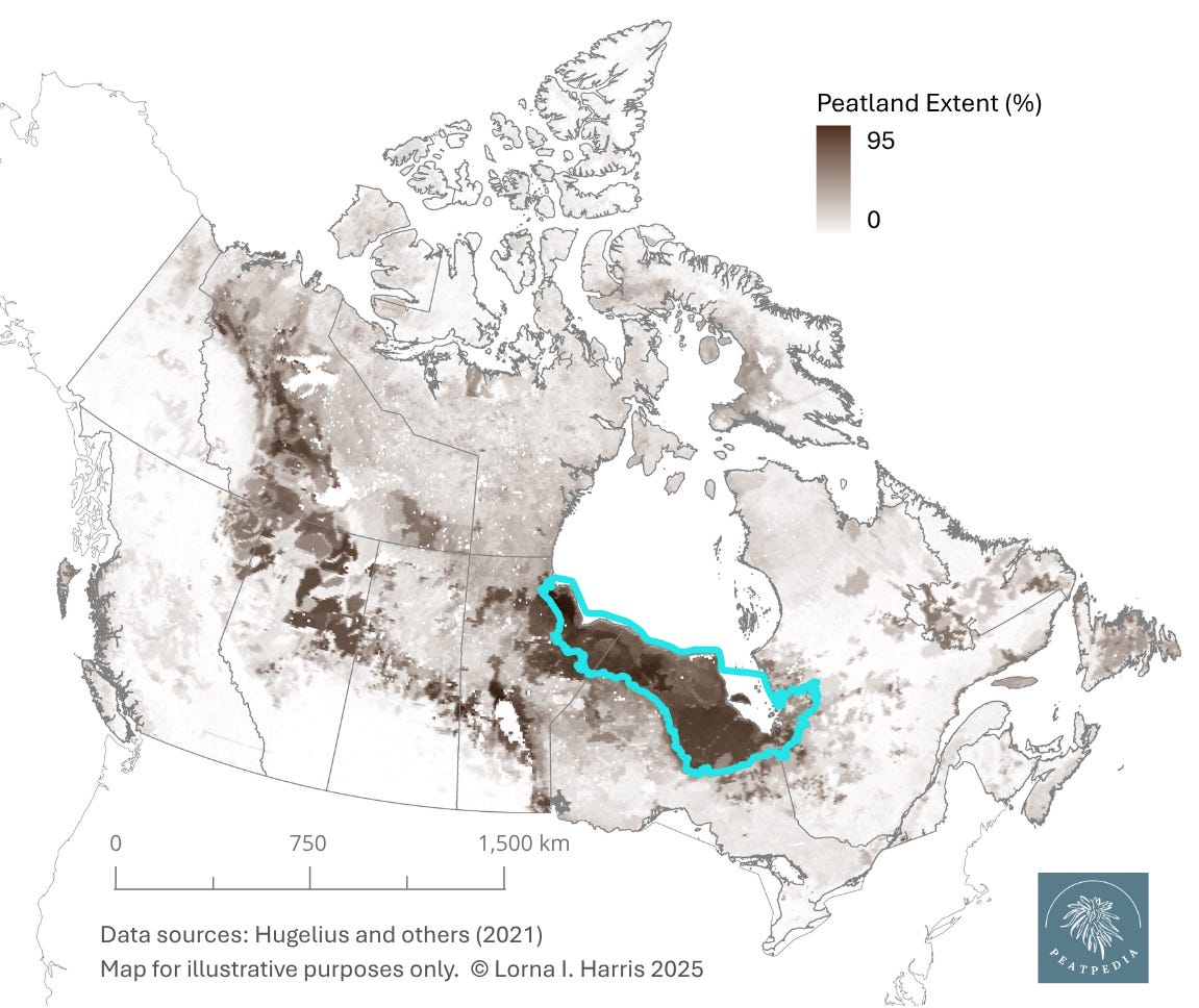
2. Hudson Bay Lowland
Peatland area: ~255,603 km2 to ~334,800 km2
Peat carbon stock: ~30 Gt C
Average peat depth: 1.85 to 2.03 m
Deepest peat: ~6 m
Oldest basal date (when peatlands started to develop): ~8,200 yrs BP
Main peatland types: bogs, fens, permafrost peatland plateaus and palsa
The Hudson Bay Lowland in Canada is North America’s largest wetland and peatland complex, the world’s second largest peatland complex, and the world’s third largest wetland. Peatlands cover between 80% (~255,603 km2) to 90% (~334,800 km2) of the Hudson Plains ecozone (area estimate of ~373,000 km2), a vast swath of low-lying terrain that extends from northern Manitoba, across the northern part of Ontario, and into part of northern Quebec. While other wetland types are present within the Hudson Bay Lowland, bogs, fens, and permafrost peatlands dominate the landscape to form near-continuous peatland cover.
Land in this region is still rising from Hudson and James Bay (the remains of the ancient Tyrell Sea) following the retreat of the glaciers so there is a distinct difference in age between peatlands nearer the coast (recently formed peatlands) and older peatlands inland. The oldest and deepest peatlands in the HBL are located inland near the margins of the Boreal Shield.
Like the West Siberian Lowland, many peatlands in the HBL have formed stunning spatial surface patterns, such as raised treed ridges and lower wet pools developing parallel to one another and perpendicular to water flow in groundwater-fed fens.
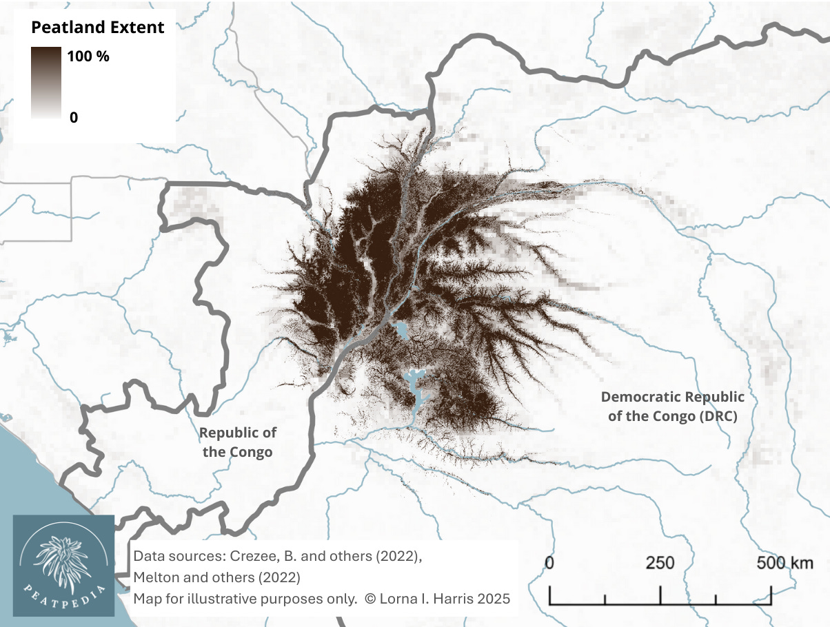
3. Congo Basin
Peatland area: ~167,600 km2
Peat carbon stock: ~29 Gt C
Average peat depth: 1.7 m
Deepest peat: ~5 m
Oldest basal date (when peatlands started to develop): ~42,300 yrs BP
Main peatland types: peat swamp forest
The peat swamp forests of the Congo Basin form the world’s largest tropical peatland complex, the world’s third largest peatland complex, and the fourth largest wetland complex. Wetlands cover ~360,000 km2 of the central Congo Basin, with ~167,600 km2 of this marsh and swamp dominated landscape confirmed as peatland.
So, where do these three massive peatland complexes fall in the list of the world’s largest wetlands?
1. West Siberian Lowland
Around 40% (just over 1 million km2) of the total lowland area (~2,745,000 km2) is wetland, with peatlands covering 592,440 km2 to 900,000 km2
2. Amazon River Basin
Wetlands cover ~840,000 km2 (14% of the total basin), with geographically separate peatland complexes and other peatland areas estimated to cover a total area of ~251,015 km2:
- Pastaza-Maranon basin peatlands (Peru) are estimated to cover ~35,600 km2 to 55,890 km2
- Rio Negro basin peatlands (Brazil) are estimated to cover ~130,000 km2 to 170,000 km2
- Bolivian Amazonia peatlands (Bolivia) are estimated to cover ~38,413 km2
- Southwestern Orinoco basin peatlands (Venezuela) are estimated to cover ~7,000 km2 to 11,412 km2
3. Hudson Bay Lowland
Total area of ~373,000 km2, with peatlands covering 255,603 km2 to ~334,800 km2
4. Congo Basin
Wetlands extend over ~360,000 km2, with peatlands covering ~167,600 km2
The list of the world’s largest wetlands continues with the Mackenzie River Basin (in northern Canada – this region contains extensive peatlands), the Pantanal (South America), the Mississippi River Basin, Lake Chad Basin, River Nile Basin, Prairie Potholes (North America’s Great Plains), and the Magellanic Moorland (Sphagnum peatlands in Patagonia).
I’ll be covering more of the world’s largest peatland complexes in future posts. Stay tuned!
References
Abraham, K.F. and Keddy, C.J. (2009). The Hudson Bay Lowland. In: Fraser, L.H. and Keddy, P.A. (2009). The World’s Largest Wetlands – Ecology and Conservation. Cambridge University Press. https://doi.org/10.1017/CBO9780511542091.005
Crezee, B., et al. (2022). Mapping peat thickness and carbon stocks of the central Congo Basin using field data. Nature Geoscience, 15. https://doi.org/10.1038/s41561-022-00966-7
Dargie, G.C., et al. (2025). Timing of peat initiation across the central Congo Basin. Environmental Research Letters, 20, 084080. https://iopscience.iop.org/article/10.1088/1748-9326/ade905
Davies, M.A., et al. (2022). Holocene carbon storage and testate amoeba community structure in treed peatlands of the western Hudson Bay Lowlands margin, Canada. Journal of Quaternary Science, 38. https://doi.org/10.1002/jqs.3465
Draper, F.C., et al. (2014). The distribution and amount of carbon in the largest peatland complex in Amazonia. Environmental Research Letters, 9. https://iopscience.iop.org/article/10.1088/1748-9326/9/12/124017
Environment and Climate Change Canada (2025). Canadian Environmental Sustainability Indicators: Extent of Canada’s wetlands. https://www.canada.ca/en/environment-climate-change/services/environmental-indicators/extent-wetlands.html
Eppinga, M.B., et al. (2008). Regular surface patterning of peatlands: Confronting theory with field data. Ecosystems, 11. https://doi.org/10.1007/s10021-008-9138-z
Harris, L.I., et al. (2020). Mechanisms for the development of microform patterns in peatlands of the Hudson Bay Lowland. Ecosystems, 23. https://doi.org/10.1007/s10021-019-00436-z
Hastie, A., et al. (2024). A new data-driven map predicts substantial undocumented peatland areas in Amazonia. Environmental Research Letters, 19. https://iopscience.iop.org/article/10.1088/1748-9326/ad677b
Hess, L.L., et al. (2015). Wetlands of the Lowland Amazon Basin: Extent, Vegetative Cover, and Dual-season Inundated Area as Mapped with JERS-1 Synthetic Aperture Radar. Wetlands, 35. https://doi.org/10.1007/s13157-015-0666-y
Keddy, P.A., et al. (2009). Wet and Wonderful: The World’s Largest Wetlands are Conservation Priorities. BioScience, 59. https://doi.org/10.1525/bio.2009.59.1.8
Kremenetski, K.V., et al. (2003). Peatlands of the West Siberian Lowlands: current knowledge on zonation, carbon content and Late Quaternary history. Quaternary Science Reviews, 22. https://doi.org/10.1016/S0277-3791(02)00196-8
Martini, I.P. (2006). Chapter 3 The cold-climate peatlands of the Hudson Bay Lowland, Canada: brief overview of recent work. In: Martini, I.P., et al. (2006). Peatlands: Evolution and Records of Environmental and Climate Changes. Developments in Earth Surface Processes. Volume 9. https://doi.org/10.1016/S0928-2025(06)09003-1
Packalen, M.S., et al. (2014). Carbon storage and potential methane production in the Hudson Bay Lowlands since mid-Holocene peat initiation. Nature Communications, 5. https://doi.org/10.1038/ncomms5078
Riley, J. (2011). Wetlands of the Hudson Bay Lowlands: An Ontario Overview.
Sheng, Y., et al. (2004). A high-resolution GIS-based inventory of the west Siberian peat carbon pool. Global Biogeochemical Cycles, 18. https://doi.org/10.1029/2003GB002190
Solomeschch, A.I. (2009). The West Siberian Lowland. In: Fraser, L.H. and Keddy, P.A. (2009). The World’s Largest Wetlands – Ecology and Conservation. Cambridge University Press. https://doi.org/10.1017/CBO9780511542091.005
Vorobyev, S.N., et al. (2025). The Great Vasyugan Mire of western Siberia: Hydrochemistry and greenhouse gas dynamics of peatland pools of the world’s largest mire. Ecological Indicators, 170. https://doi.org/10.1016/j.ecolind.2024.113054
This is very interesting, whilst als highlighting the dangers of blind trust in AI when asking questions! Those areas covered in each complex are just huge!